

Vantara map is one of the first things you should check before planning your visit. It helps you understand the overall layout of the wildlife conservation center, locate important areas, and make your trip more organized. Whether you’re visiting for the first time or simply looking for information, knowing how the campus is arranged can save both time and effort.
What Is Vantara?
Vantara is a large-scale wildlife rescue, rehabilitation, and conservation center located in Jamnagar, Gujarat. It has been developed to provide medical care, shelter, and long-term support for rescued, injured, and endangered animals. The facility is designed to offer natural habitats along with advanced veterinary care, making it one of the most significant wildlife conservation projects in India.
Its primary mission is to protect wildlife, support animal welfare, and create a safe environment where rescued animals can recover and thrive.
Why Is the Vantara Map Important?
A large wildlife campus can be difficult to explore without understanding its layout. The Vantara map gives visitors a clear idea of where different sections are located, making it easier to navigate the premises.
By checking the map before your visit, you can plan your route, estimate travel time between different areas, and identify important visitor facilities. It also helps you avoid unnecessary walking and ensures you don’t miss key attractions.
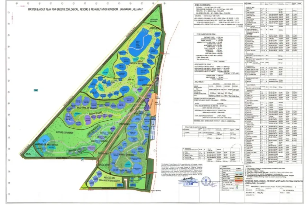
What Can You Find on the Vantara Map?
The Vantara map usually highlights the major sections of the campus and the facilities available for visitors. While the exact layout may vary over time, some common areas include:
Main Entrance
The main entrance is where visitors begin their journey. It serves as the primary access point and often includes information counters, security checks, and visitor guidance.
Wildlife Conservation Zones
These are the heart of the Vantara campus. Different animal species are housed in carefully designed environments that closely resemble their natural habitats while ensuring their safety and well-being.
Veterinary Hospital
One of the most important parts of the facility is its advanced veterinary care center. This area is dedicated to the treatment, rehabilitation, and recovery of rescued animals. Public access may be restricted in certain sections to ensure the animals receive proper care without disturbance.
Administrative Buildings
These buildings manage the daily operations, conservation programs, and overall administration of the wildlife center.
Visitor Facilities
The map may also indicate parking areas, restrooms, drinking water points, waiting areas, and other essential amenities that make the visit more comfortable.
How to Use the Vantara Map Before Your Visit
Reviewing the Vantara map in advance allows you to plan your visit more efficiently. Start by identifying the entrance, visitor services, and the main attractions you want to explore.
If the campus is large, it helps to prioritize the sections you’re most interested in. This approach saves time and allows you to enjoy the experience without feeling rushed.
It’s also a good idea to understand the walking routes and available facilities before arriving, especially if you’re visiting with children or elderly family members.
Where Is Vantara Located?
Vantara is located in Jamnagar, Gujarat, India. The city is well connected by road, rail, and air, making it accessible for visitors from different parts of the country.
After reaching Jamnagar, local transportation options can help you reach the wildlife conservation center conveniently. Before traveling, always check the latest visitor information and route details to avoid unexpected delays.
Things to Keep in Mind While Using the Vantara Map
The Vantara map is meant to help visitors move around the campus smoothly while respecting conservation guidelines. Some areas may have restricted access for safety or animal welfare reasons, so it’s important to follow all instructions provided by the management.
Stay on designated paths, avoid entering restricted zones, and respect the rules established to protect both visitors and wildlife.
Is the Vantara Map Available Online?
Depending on official updates, visitors may be able to access the Vantara map through official information channels before planning their trip. Checking the latest available map can help you understand the current layout, visitor routes, and any changes in access.
Using updated information ensures that your visit is well planned and free from unnecessary confusion.
Also read: Vantara Animal Kingdom: A Complete Guide to India’s Unique Wildlife Conservation Project
Tips for First-Time Visitors
If you’re visiting Vantara for the first time, wear comfortable clothing and walking shoes, as exploring a large campus may involve considerable walking. Carry drinking water if permitted and plan enough time to enjoy the experience at a relaxed pace.
Always follow visitor guidelines, avoid making loud noises around animals, and respect photography rules if certain areas have restrictions.
Conclusion
The Vantara map is an essential resource for anyone planning to visit this remarkable wildlife conservation center. It helps visitors understand the campus layout, locate important facilities, and organize their trip more efficiently. By reviewing the map beforehand, you can make the most of your visit, save time, and enjoy a smoother, more comfortable experience while exploring one of India’s most ambitious wildlife conservation projects.
Also read: Reliance Vantara: Inside India’s Largest Wildlife Rescue and Conservation Initiative